You are using an out of date browser. It may not display this or other websites correctly.
You should upgrade or use an alternative browser.
You should upgrade or use an alternative browser.
Just take a few "quiet" minutes and simply think about it.
- Thread starter Sourdough
- Start date
Help Support Homesteading & Country Living Forum:
This site may earn a commission from merchant affiliate
links, including eBay, Amazon, and others.

- Joined
- Oct 18, 2020
- Messages
- 1,233
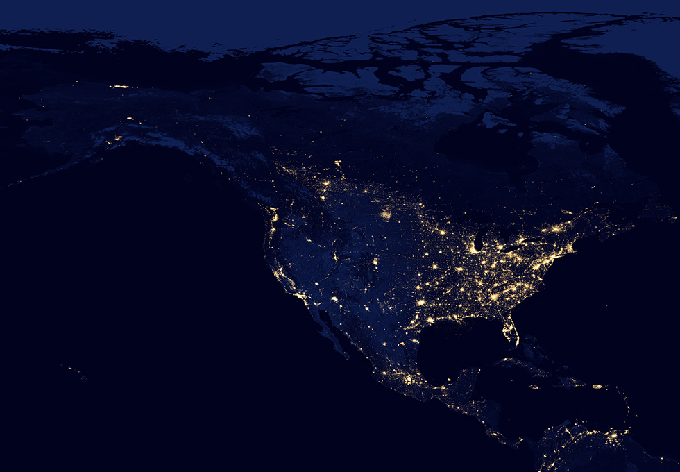
Since there was some debate a few days ago about whether Australia or New Zealand are any safer than the US, here is an image of both those nations at night.

Can someone upload Alaska at midnight. Please
- Joined
- Oct 18, 2020
- Messages
- 1,233
Can someone upload Alaska at midnight. Please

I do get where you’re going SD but there’s a part of me - well, pretty much all of me that is saddened by that pix. It’s so far past natural and has happened so quickly (say 50ish years). Would be interesting to see the same from 50 years ago.
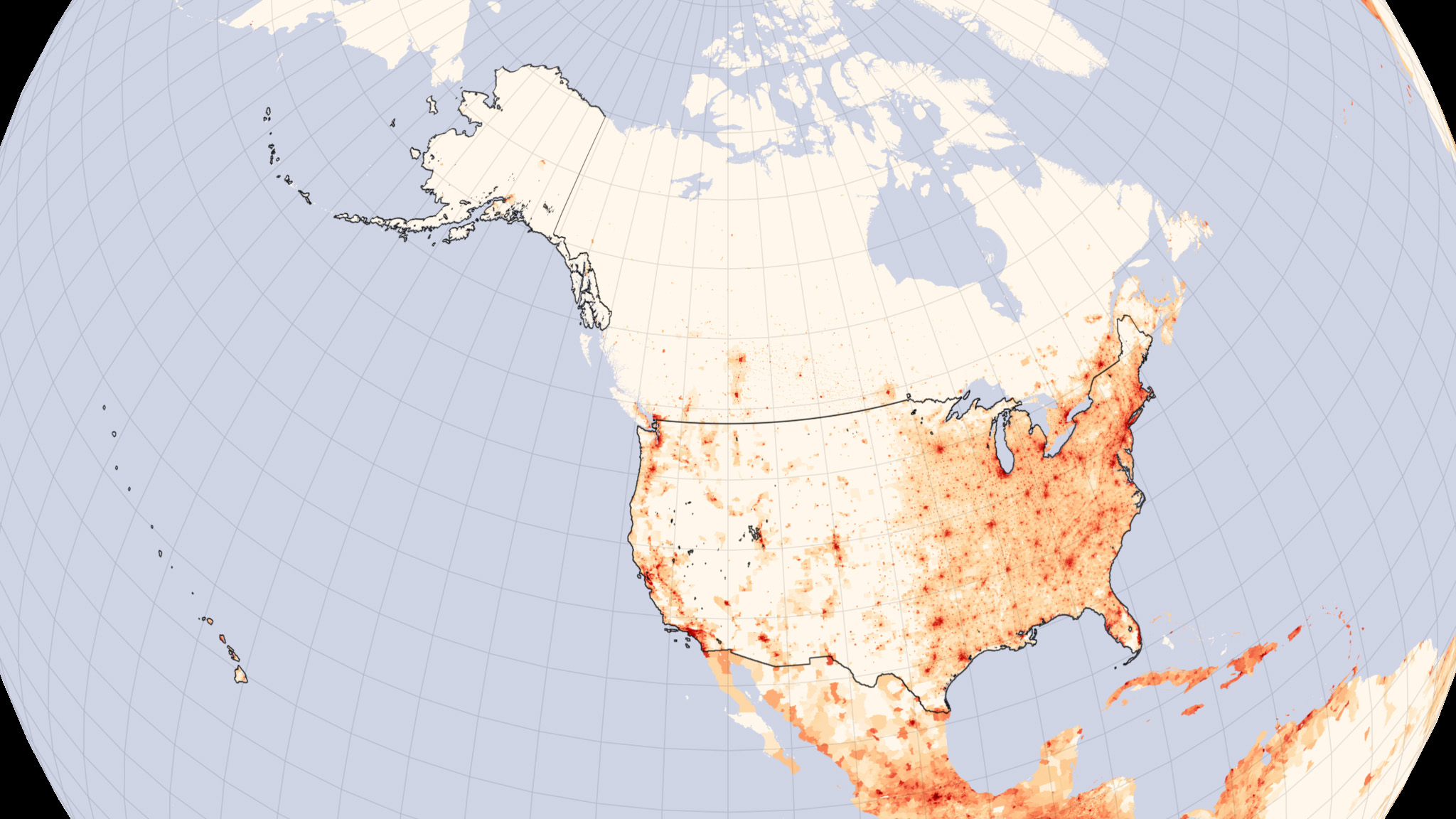
US population
- Joined
- Dec 3, 2017
- Messages
- 18,305
Glad I'm living mostly in the dark
Looking DOWN at a point on Earth is exactly the opposite of what you see when you look UP from that same point on Earth.
Thanks. It is as I expected.....accept I am very surprised at how much light is coming from KENAI and SPLDOTNA twin cities. WOW.
- Joined
- Oct 18, 2020
- Messages
- 1,233
Bear in mind that, for images that are exposed to relatively low light intensity overall (like the Alaska and Australia/New Zealand images), the camera compensates by opening up the iris and/or using a longer exposure - so the sensitivity to mild/small light sources will be increased.Thanks. It is as I expected.....accept I am very surprised at how much light is coming from KENAI and SPLDOTNA twin cities. WOW.
That lower US image is actually an understatement of the amount of delinguent light emitted by towns and cities. If you turned off the Eastern side of the country, then the flyover states would light up as the camera settings changed.
Bear in mind that, for images that are exposed to relatively low light intensity overall (like the Alaska and Australia/New Zealand images), the camera compensates by opening up the iris and/or using a longer exposure - so the sensitivity to mild/small light sources will be increased.
Maybe. For your handheld point-n-shoot. Possibly not for the more sophisticated cameras mounted in satellites.
Other differences could be due to post processing - the person posting the image on a website changes the exposure to make things look better to their eye. Easy to do in PhotoShop or any other image editing software (same image in each picture below, just duplicated the main layer and blended in screen mode twice):

I can confirm. I've spent many nights at 35,000 feet watching out the window of a 737. Once you get west of Omaha, Kansas City, and Dallas/Ft. Worth, the ground gets dark real quick. It's the smaller towns that make the map seem like one continuous light source - they're so close it's almost like they're interconnected when you're out east. Out west, they're 25 to 50 miles apart, or more...
What that shows me is the Eastern half of the country, and the Western coastal region, is not where I want to live. Too many lights equals too many people.
It also shows me the probability of a military attack will be the Western coastal cities and the larger cities in the Central and Eastern United States.
Finally, Americans are too fond of illumination. Everything must have a light and the light must be on at night. And now street lights and porch lights are not good enough so they have solar pathway lights around their entire property, their driveway, their house, and in the backyard. Even if they are asleep they want lights to shine bright.
Wow, this looks like a great place to live!

North Korea
North Korea
- Joined
- Oct 18, 2020
- Messages
- 1,233
You are assuming the only criteria for targeting will be population density - it most likely will not...............
It also shows me the probability of a military attack will be the Western coastal cities and the larger cities in the Central and Eastern United States.
.........
The number one priority in an attack will be to destroy military capability - and a lot of that is intentionally located out in the middle of nowhere. Hitting population centers will be somewhere down the priority list from there......
If you want to identify the safest location, you need to work out what other legit targets are in each area and what the dominant wind direction from those sites will do to fallout.
Even when you do that, there is significant risk that the wind won't be blowing that way at the critical times.
That is the appeal of going somewhere a very long way away from likely targets (both civilian and military) - you don't need to be so very lucky to survive a nuclear war.
Last edited:
I remember seeing a photo of America at night in 1993 when I first went out there. I'm surprised at the rapid expansion.
- Joined
- Dec 9, 2017
- Messages
- 12,684
While looking to find a 1990 to current comparison, as suggested above!.. Found a world night view composite because it is not night everywhere at once ")

- Joined
- Jun 25, 2020
- Messages
- 1,531
No light pollution where we are. Closest neighbor is 1/2-mile away.
I understand your point. I had a training class years ago that listed the 6 largest cities in the USA that were (supposedly) high priority targets. New York, Chicago, Houston, Dallas, and Los Angeles, and I think they also included DC. Of course large and strategic military basis would be targets but many of them are not in highly populated areas. Nellis AFB is near Las Vegas but the population numbers are not that significant. Area 51/Nevada Test Site is very isolated. Both of those pose the most concern to where I live down wind. Strategic sites in Wyoming and Montana are also very isolated.You are assuming the only criteria for targeting will be population density - it most likely will not.......
The number one priority in an attack will be to destroy military capability - and a lot of that is intentionally located out in the middle of nowhere. Hitting population centers will be somewhere down the priority list from there......
If you want to identify the safest location, you need to work out what other legit targets are in each area and what the dominant wind direction from those sites will do to fallout.
Even when you do that, there is significant risk that the wind won't be blowing that way at the critical times.
That is the appeal of going somewhere a very long way away from likely targets (both civilian and military) - you don't need to be so very lucky to survive a nuclear war.
Anything could be claimed as a valuable target depending on what damage an enemy would want to inflict. Taking out people and infrastructure would be much more effective in a highly populated city.
I came across this video a few days ago and it is very much in line with the discussion here.
I'm honestly very happy that our homestead is in that empty block!
I'm honestly very happy that our homestead is in that empty block!
- Joined
- Oct 18, 2020
- Messages
- 1,233
As I mentioned in a recent post, there are at least a few thousand nuclear weapons aimed at the US.I understand your point. I had a training class years ago that listed the 6 largest cities in the USA that were (supposedly) high priority targets. New York, Chicago, Houston, Dallas, and Los Angeles, and I think they also included DC. Of course large and strategic military basis would be targets but many of them are not in highly populated areas. Nellis AFB is near Las Vegas but the population numbers are not that significant. Area 51/Nevada Test Site is very isolated. Both of those pose the most concern to where I live down wind. Strategic sites in Wyoming and Montana are also very isolated.
Anything could be claimed as a valuable target depending on what damage an enemy would want to inflict. Taking out people and infrastructure would be much more effective in a highly populated city.
None of us can know how far down the list of priorities places could be and still get hit.
People should avoid having an unrealistically optimistic view about where the closest place hit (to them) might be.
If the button is ever pushed, those who didn't make it would be the lucky ones. I hear earth would be uninhabitable for 20 or more years.
- Joined
- Oct 18, 2020
- Messages
- 1,233
Some of those who don't make it will be killed instantly.If the button is ever pushed, those who didn't make it would be the lucky ones. I hear earth would be uninhabitable for 20 or more years.
Most however, will die a slow and painful death.
It is better to not be in either group.
You can prepare your way up to and through any crisis - but it will take a lot more than luck or just writing about it on discussion forums.
Quitters never win and winners never quit.
I will be trying to survive any crisis that comes along (even if only out of principle) until I draw my last breath.
Thank you! So many folks don't get that. Folks from back east and even family from Calif. laugh because when someone askes how far away a given place is, the answer often comes in the form of time. How far away is XYZ? About an hour. It depends not just on distance but roads, mountains, and weather.I can confirm. I've spent many nights at 35,000 feet watching out the window of a 737. Once you get west of Omaha, Kansas City, and Dallas/Ft. Worth, the ground gets dark real quick. It's the smaller towns that make the map seem like one continuous light source - they're so close it's almost like they're interconnected when you're out east. Out west, they're 25 to 50 miles apart, or more...
I simply feel blessed that I can look up and see the Milky Way and all of the stars just as clear as our forefathers did.
Looking at the map of Florida, you can see where all the Yankees are moving to.I remember seeing a photo of America at night in 1993 when I first went out there. I'm surprised at the rapid expansion.
I grew up and spent over half my life in one of those bright areas, in 1995 was Blessed by the Lord to be able to move to one of the dark spots.
I was laughing as I read this, because some of those same city folks have to do the same thing when simply going to the grocery store. When I was stuck living in Las Vegas it would take me 20 minutes to go 2 miles to the grocery store because traffic was so bad and it would take 3 or 4 light cycles to get through an intersection. The traffic issues in California with the commuters taking hours on the freeways to travel 60 miles each way to work have the same issues.Thank you! So many folks don't get that. Folks from back east and even family from Calif. laugh because when someone askes how far away a given place is, the answer often comes in the form of time. How far away is XYZ? About an hour. It depends not just on distance but roads, mountains, and weather.
But, here where I live now I get to say things like 30 minutes to town, or 12 minutes to the small town north of here. Both at 65mph on the 2 lane highway, unless it is snowing and I slow down to about 40mph just to me safe.
- Joined
- Feb 11, 2022
- Messages
- 598
Not this Yankee , I am in nys. I live in the Catskill mountains , no cities ,nearest small town is ten miles away, no neighbors that I can see .Looking at the map of Florida, you can see where all the Yankees are moving to.
I grew up and spent over half my life in one of those bright areas, in 1995 was Blessed by the Lord to be able to move to one of the dark spots.
because of nyc we get a bad rap . nearest small city is 90 min. away. I'm in the dark part . Never been to nyc and never will.
Landscape wise New York State is one the most beautiful in America. I especially love the Finger Lakes Region, and Southern Tier.
Not this Yankee , I am in nys. I live in the Catskill mountains , no cities ,nearest small town is ten miles away, no neighbors that I can see .
because of nyc we get a bad rap . nearest small city is 90 min. away. I'm in the dark part . Never been to nyc and never will.
Nearest large point of light would be El Paso, 75-80 miles away from my home... with Fort Bliss just this side of it. Holloman AFB is closer, just WSW of Alamogordo, but not close enough for me to worry about either, I could easily dodge the fallout from both installations if they were bombed. One thing nice about living in the boondocks: roads are wide open here, traffic-wise, so I can make tracks in a hurry if necessary. If things ever get out of hand in El Paso, Fort Bliss will provide a "buffer zone" to quell unrest, lol. Otherwise, I have a huge mountain range full of wildlife right nearby, and plenty of field gear for a bug out situation. I really like being on a community well too, here at the ol' hacienda... no reliance or dependence upon town water. The way I see it, there'd be heaps of unrest in other locations long before it cropped up here... and we have plenty of armed rednecks to keep unrest to a minimum. I'm one of 'em, lol...
Joel Skousen wrote STRATEGIC RELOCATION, and he thinks the 'Intermountain West' offers the best chances of survival for many SHTF scenarios... looking at his maps and the pic posted by the OP, you can see how they are aligned in terms of survival. I'm not talking about the cities either, or even the larger towns, the safest places will be in the boondocks. Nuclear fallout moves with the weather pattern and prevailing winds, it doesn't hang about as some folks mistakenly believe... they confuse fallout with the "half-life" of certain radioactive elements or isotopes. Not the same animal... but either one can still kill you over time, lol. As long as you are 10 miles or so outside the immediate blast area, you stand a good chance of short-term survival as long as you dodge the fallout. Knowing the strategic targets and remaining aware of current weather patterns will aid in survival, and as a lifelong sailor I keep tabs on wind direction...
Another fact: precipitation can help knock down fallout sooner than expected, so that's something to consider. I can't rely upon rain here in the high desert, though it's raining right now as I key this reply, lol. Meh, those who are interested can check out STRATEGIC RELOCATION, it offers a wealth of information... Skousen also wrote books on secure & self-sustaining homes. His books are blacklisted due to his anti-gubmint views, and he was a Marine fighter pilot, go figure... he also helped to design a lot of the "bunker complexes" in this country, so he has seen all sides of the proverbial coin, including the edge, lol. When I first pinged upon Skousen's work, I couldn't find a SINGLE COPY of STRATEGIC RELOCATION on any library shelf in San Diego County... ya gotta special order it, aye? But his work has been a major factor in my decisions to buy real estate in Arizona & New Mexico, once I left the overcrowded coast for good, 10-4?